
Some of our stops are not marked with a bus stop sign. This page gives details of all of our regular stops. For each stop, there is a street view showing the location of the stop marked with a green circle, a link to the Google Street View of the bus stop, a link to OpenStreetMap showing the exact location of the stop marked with a blue pin, and a what3words link to the exact location.
West Meon – Thomas Lord PH
This stop is marked by a bus stop sign and bus shelter.
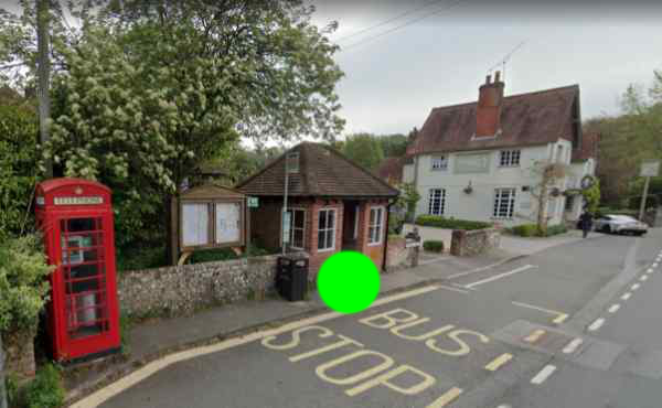
Image Copyright 2025 Google. Click here to see Google Maps Street View.
Click here to view on OpenStreetMap.
what3words: ///reapply.copies.servicing
Warnford – Village Hall
The stop is opposite the main entrance of the village hall. The bus will always be travelling south on Lippen Lane (towards the camera in the street view below).
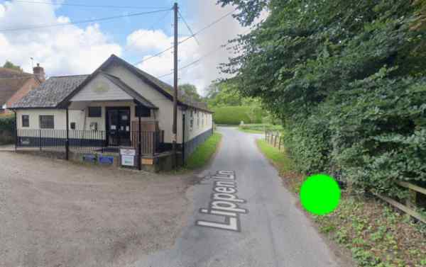
Image Copyright 2025 Google. Click here to see Google Maps Street View.
Click here to view on OpenStreetMap.
what3words: ///crown.offerings.finders
Warnford – George and Falcon
This stop is marked by a bus stop sign outside the entrance to the George and Falcon car park.
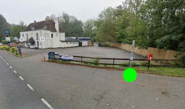
Image Copyright 2025 Google. Click here to see Google Maps Street View.
Click here to view on OpenStreetMap.
what3words: ///rarely.aimlessly.clearing
Exton – The Shoe PH
The bus stop is by the phone box opposite “The Shoe” public house for the southbound service to Fareham (marked S), and at the edge of “The Shoe” car park for the northbound service to Winchester (marked N).
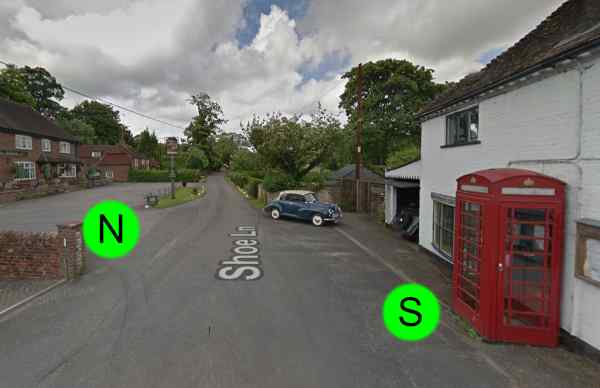
Image Copyright 2025 Google. Click here to see Google Maps Street View.
Click here to view northbound (N) on OpenStreetMap.
Click here to view southbound (S) on OpenStreetMap.
Northbound (N) what3words: ///celebrate.hurricane.random
Southbount (S) what3words: ///edits.upholding.schools
Corhampton De Port Heights
This stop is on the A32 opposite the entrance to De Port Heights, and is marked by a bus stop sign including the name “De Port Heights” on the sign.
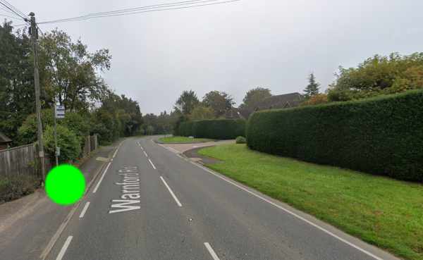
Image Copyright 2025 Google. Click here to see Google Maps Street View.
Click here to view on OpenStreetMap.
what3words: ///internal.estuaries.munch
Meonstoke PO & Stores
This stop is in the lay-by adjacent to Meonstoke Post Office and Stores for southbound service to Fareham (marked “S” in the picture below).
For the northbound service to Winchester, the stop is on Allens Lane outside the Meonstoke Post Office and Stores (marked “N” in the picture below).
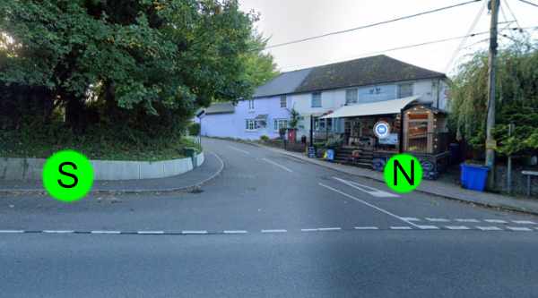
Image Copyright 2025 Google. Click here to see Google Maps Street View.
Click here to view southbound (S) on OpenStreetMap.
Click here to view northbound (N) on OpenStreetMap.
Northbound (N) what3words: ///mows.caressed.loads
Southbount (S) what3words: ///pulp.sweeten.excusing
Meonstoke – Pound Cottages
This stop is next to the disabled parking space nearest to the entrance of Pound Cottages. The bus will enter Pound Cottages, drive past the bus stop, then turn round before stopping at the bus stop.
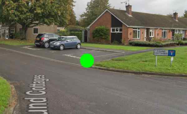
Image Copyright 2025 Google. Click here to see Google Maps Street View.
Click here to view on OpenStreetMap.
what3words: ///deflated.interval.taps
Droxford Square
This stop is at the entrance to Droxford Square. The bus will approach from the north and turn into the square. Please note that the bus will stop in the square, not next to the bus shelter on the A32.
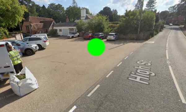
Image Copyright 2025 Google. Click here to see Google Maps Street View.
Click here to view on OpenStreetMap.
what3words: ///metro.plump.outcasts
Brockbridge – The Hurdles
The stop is along Station Road near the junction with the B2150, where the road is slightly wider. The bus will come from the B2150, travelling south on Station Road (towards the camera in the picture below) for the service to Fareham (marked “S”). It will be travelling north on Station Road for the Petersfield and Winchester services (marked “N”).
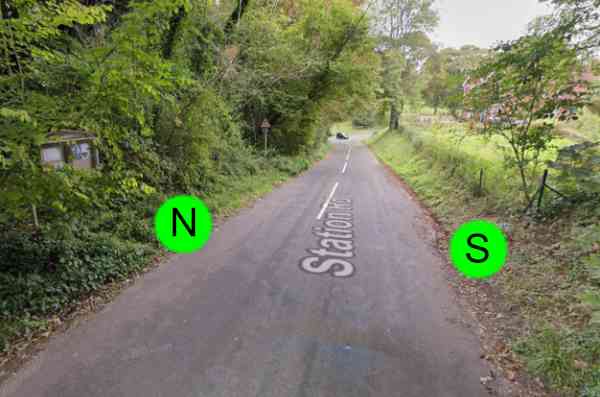
Image Copyright 2025 Google. Click here to see Google Maps Street View.
Click here to view southbound (S) on OpenStreetMap.
Click here to view northbound (N) on OpenStreetMap.
Northbound (N) what3words: ///premature.submit.clipboard
Southbount (S) what3words: ///earplugs.panting.dislikes
Soberton Village Hall
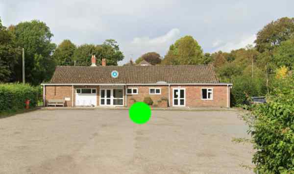
Image Copyright 2025 Google. Click here to see Google Maps Street View.
Click here to view on OpenStreetMap.
what3words: ///calendars.eyelash.bothered
Webbs Green War Memorial
This stop is next to the bench opposite the war memorial at the junction where Webbs Green, High Street and Selworth Lane meet.
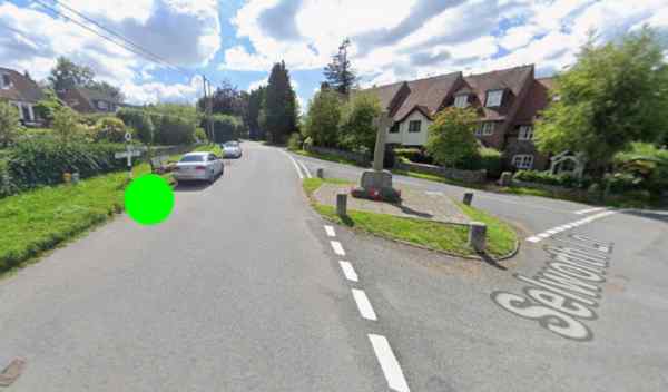
Image Copyright 2025 Google. Click here to see Google Maps Street View.
Click here to view on OpenStreetMap.
what3words: ///canoe.shifts.roaming
Soberton Heath – Chapel Road pond
The bus stop is located on Chapel Road by the grass verge opposite the bench overlooking the pond at the junction of Chapel Road, Heath Road and Horns Hill.
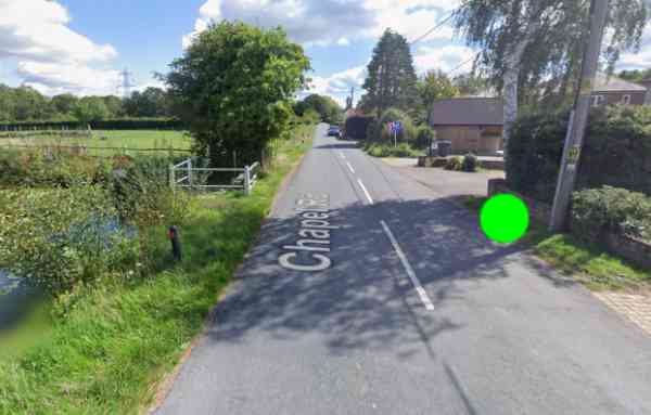
Image Copyright 2025 Google. Click here to see Google Maps Street View.
Click here to view on OpenStreetMap.
what3words: ///mattress.grazes.inherits
Soberton Heath – Bold Forester PH
The stop is on Heath Road, near the Bold Forester. The bus will be travelling along Heath Road towards Liberty Road and will stop just after the junction with Forester Road.
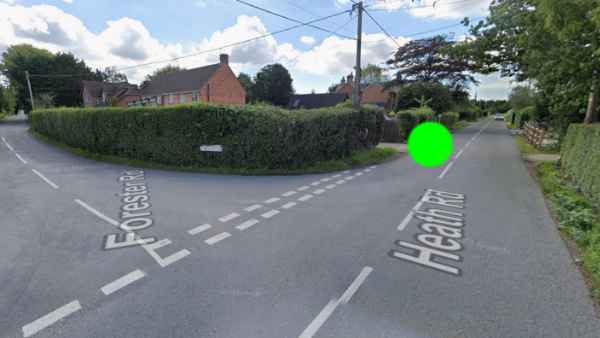
Image Copyright 2025 Google. Click here to see Google Maps Street View.
Click here to view on OpenStreetMap.
what3words: ///redouble.promotes.alternate
Newtown – Rookesbury Hall
The bus stops on Church Road, opposite Rookesbury Hall. There is a pole with no sign attached marking the bus stop.
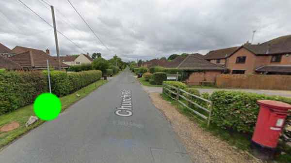
Image Copyright 2025 Google. Click here to see Google Maps Street View.
Click here to view on OpenStreetMap.
what3words: ///defended.lengthen.pints
Hundred Acres
This stop is next to the postbox on Hundred Acres Road, at the junction with Hundred Acres private road.
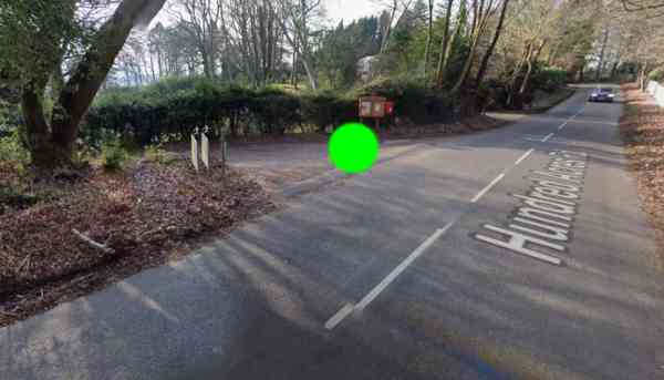
Image Copyright 2025 Google. Click here to see Google Maps Street View.
Click here to view on OpenStreetMap.
what3words: ///jogged.lyrics.logic
Fareham Library
The bus stop is next to Fareham Library (by “New Look”).
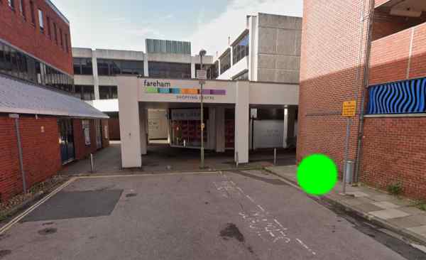
Image Copyright 2026 Meon Valley Bus. Click here to see Google Maps Street View.
Click here to view on OpenStreetMap.
what3words: ///reclusive.lateral.beakers
Fareham Sainsbury’s
This stop is located at the “pick up point” outside Sainsbury’s.
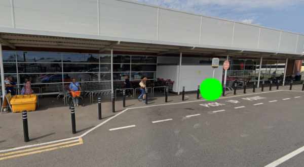
Image Copyright 2025 Google. Click here to see Google Maps Street View.
Click here to view on OpenStreetMap.
what3words: ///hands.outbound.noticing
Petersfield Square
Both stops are marked as bus stops with shelters and signs “A” and “B”. On the outbound journey, the bus stops at stop A (near “Specsavers”); on the return journey it stops at stop B (near “Oxfam”).
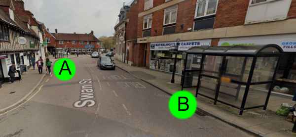
Image Copyright 2025 Google. Click here to see Google Maps Street View.
Click here to view stop A on OpenStreetMap.
Click here to view stop B on OpenStreetMap.
Stop A what3words: ///firewall.listen.clipped
Stop B what3words: ///surveyors.crowds.ending
Petersfield Tesco
The stop at Petersfield Tesco is located at the entrance to Tesco car park, clearly marked “G” and has a bus shelter.
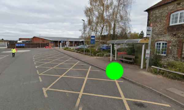
Image Copyright 2025 Google. Click here to see Google Maps Street View.
Click here to view on OpenStreetMap.
what3words: ///purple.height.reset
Winchester The Broadway (Stand 7)
The bus stops at stand 7 on The Broadway. This is the stand closest to King Arthur’s Statue.
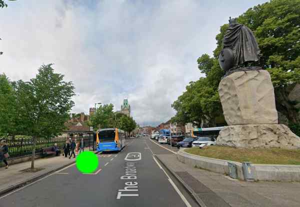
Image Copyright 2025 Google. Click here to see Google Maps Street View.
Click here to view on OpenStreetMap.
what3words: ///mountains.wonderful.bachelor
Winchester River Park Leisure Centre
Outside River Park Leisure Centre, in the “Buses Only” bay.
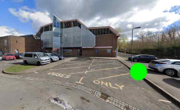
Image Copyright 2025 Google. Click here to see Google Maps Street View.
Click here to view on OpenStreetMap.
what3words: ///payback.housework.combining